Showing posts with label suffolk county. Show all posts

Friday, 16 September 2011

Merit


My days in Greenport often include numerous visits to the commercial fishing dock. I never plan it that way, but after an early morning walk up Front Street for coffee and a newspaper, a short detour along the waterfront usually seems like a good idea. 


Many of the boats have already left for the day, but a few remain behind to work on their gear. One boat appears to have a never-ending problem with her starboard engine. I keep a low profile and linger for only a short time. Making my way to the end of the pier, I gaze across to Shelter Island and her approaching ferry reflecting in the sunrise.
Later in the day, I often walk this pier again; creating a matching bookend to my day on the North Fork. Many of the boats have now returned, leaving the docks wet and slippery, with the smell of fish filling the air. I make a conscious effort to stay out of their way.


Every so often, I'm recognized by a fisherman who saw me here previous times. They give me a strange look, and I am never quite sure if they think I am an inspector, or just some bored tourist who doesn't know what to do with his time.
I really should tell him that I'm just someone who likes old boats and fresh fish!


Wednesday, 7 September 2011

Phragmites Park


At the southern tip of Northport Harbor is the eleven-acre Phragmites Park. Wedged between some residential neighborhoods, the entrance to the preserve is easy to miss when traveling along Route 25A. Like many coastal access spaces, this nature area is known by several names, including Twin Ponds Park and most recently, Betty Allen Preserve-North.


Once used as a dumping site for the dredged spoils from nearby bays, this stretch of shoreline began an extensive wetlands restoration project in 2002. While I'm certainly not an authority on the subject, the results appear to be a notable success.


I've always had a soft spot in my heart for the Northport area. It's a pretty harbor with an attractive and walkable waterfront, populated by a citizenry which appears committed to maintaining it. My afternoon spent at Phragmites Preserve only reinforced this belief.


Pbase: Northport Photos

Wikimapia: Betty Allen Preserve

NYNJCT Botany: Hiking Betty Allen/Twin Ponds

Note: I didn't visit the area south of Rte 25A. That will have to be done another time

Thursday, 14 July 2011

Bright Sky, Big Erratics


I have a love-hate relationship with rocks. As they say on Facebook...."it's complicated"
Aboard Carina, I don't want to see them, yet I find myself thinking of them all the time. And when I don't see them, it only makes things worse: I know they are out there lurking just beneath the surface, ready to confront my keel when I least expect it.  Big rocks don't like me, and I don't like them. Even worse, if I were to run into them, I know I'll never win.
But once ashore, I can never stay angry for very long. I suppress the destructive, bad times and become seduced again by their polish and form. I take all sorts of pictures and send them to my friends......trying to convince everyone, including myself, things will be different from now on.


While glacial erratics are found throughout Long Island Sound, they are especially abundant along the eastern  portion of the Suffolk County shoreline. Walking the beaches of Wildwood, Wading River, and Horton Point  provides a crash-course in the geological history of North America. 
They are very pleasing to look at........  from shore.


Garvies Pt Museum: Geology of Long Island
Hofstra University: L.I. Geology
The Outer Lands: A Natural History Guide (Cape Cod to Long Island)

Wednesday, 6 July 2011

Miss Patty


Returning home, the lobster boat Miss Patty navigates the Mattituck Creek.


Soundbounder: Phyllis Ann

Thursday, 23 June 2011

Mill Dam Bridge in Centerport


Spanning the tidal-flats of Centerport Harbor, the Mill Dam Bridge has a history as old as our country itself. A tide-mill and dam were constructed here in 1774, which replaced an earlier mill built just south of this site in 1674.  Although the mill is long gone, the bridge and dam have been reincarnated several times in the last century. 
Its most recent form, built in 2005, may be the most inviting. Designed with accessibility and aesthetics in mind, there is stonework and detail often not found in public works today. At several points, the sidewalks widen to create viewing areas of both the harbor and the sluice gates below. Both ends of the bridge have small pocket-parks with benches, and various bric-a-brac. 


It's not just a utilitarian bridge and dam - it's a place to spend a little time. It's the Camden Yards of Long Island Sound bridges.


I suppose Centerport Harbor is one of those settings that would be beautiful regardless of the bridge which was built. Still, it is nice to see structures which compliment the surroundings, rather than detract. And it's especially heartening to see city fathers and planners trying to appeal to public-access kooks like me. 


Jarvis House: Mill Dam Bridge (Lori put together a collection of wintertime photos)
Boating Times: Centerport Harbor


photo credit: Wikipedia


Saturday, 30 April 2011

Ashore On Fire Island III


Unless television has lied to me, the surest way to make something disappear is to hire an excavator from Ronkonkoma. Yesterday, almost a month after she ran aground, bulldozers and backhoes used brute force to move Le Papillion down the beach and north across the island through a pathway known as the cut.  The hull suffered damage in the process.
I'm not sure what happens next, or how she will be transported off the island.


Thanks to RK8776 at Noreast.com for the photo.
Tugster: Ashore 6
Frank Markus: Removal Gallery

Thursday, 28 April 2011

Fleet's Cove Beach


It's an unintentional habit of mine to be out the door much earlier this time of year. I wake-up at the same hour, but the 6 a.m. sunrise and warmer temperatures seem to get me moving much sooner. No need to be reading an upteenth story about Donald Trump, when instead, I could be somewhere such as Fleet's Cove Beach, in the Centerport section of Huntington.
Early mornings in spring bring the usual small group of stereotypes to the beach: there's the retiree with the metal detector; a jogger or two (one looks like he needs the exercise, the other doesn't); the inevitable guy on a cell phone while walking a labrador retriever; and the pouty woman with pricey athletic wear, performing some sort of new-age exercise which I am not familiar with. Housewives of Huntington?


But just beyond the beach, maybe 100 feet from the shoreline, was someone standing with water up to his waist. His back was turned to me so at first it didn't register, but then I saw the waders and rake, and knew he was digging for clams.


He went about his work rather methodically, tossing the stones and smaller shellfish from each dig back in the water, and keeping one or two. His path seemed predetermined, as he would concentrate his digging in particular areas while completely ignoring others altogether. As he made his way westward, I thought about taking a picture before he was out of view, but  decided against it. I didn't want to intrude on his privacy or interfere with his early morning solitude. He looked at peace with his surroundings and his work and who was I to disrupt that?


And besides, Ms Tai Chi Versace Lady might have felt jilted if she discovered someone else receiving more attention than  she.


Fleet's Cove is one of eight beaches operated and maintained by the Town of Huntington. From late May through early September, a permit is required for visitation. Located at the western end of Northport Bay, it provides a panoramic view of both Eatons and Lloyd Neck which extend northward along the massive Huntington Bay.


Lori at Jarvis House has some great photos from a visit this winter.
Town of Huntington: Permits and Fees


Friday, 22 April 2011

Fire Island Schooner Update


I've been unable to make a return visit to Fire Island for an update on the schooner? Le Papillon, which has been beached at Saltaire for over three weeks now.
Thanks to the wonders of the internet, Tugster, Saltaire38, and Frank Markus have provided some photos of her from last weekend. With each passing day, she looks less like a beached schooner, and more like a shipwreck.


Tugster: Ashore 4

Saltaire 38: After An April Storm

Frank Markus: Photo Gallery


Soundbounder: Ashore On Fire Island


photo credit: Frank Markus, copyrighted (top); Tugster (bottom)


Le Papillon in better days. I received an email last week from Shirley who knows the boat well. She wrote: "I sailed with her in Moorea some years ago & wondered where in the world the schooner was now. I attached one of the photos I took that year."

?

Tuesday, 29 March 2011

Wolf Larsen


Sometimes when snowflakes are falling and the winds are howling, I find myself thinking about Wolf Larsen. No, not the antagonistic character from the Jack London novel Sea Wolf, but instead a former fishing rig of the same name, anchored in the Price's Bend section of Northport Harbor. Brutal and cynical, yet also highly intelligent, she is appropriately named.
I first saw Wolf Larsen several summers ago while anchored here waiting for an August storm to pass. Her outriggers and design stood apart from the cabin cruisers and sailboats surrounding her. There was no activity aboard, and it appeared that there hadn't been any in a long time. Cormorants and herons had assumed ownership with two large nests atop the pilot house. 
Returning here again (by land) in early December, the other boats were long gone, but not Wolf Larsen. There she was, still moored, with her bow pointing into the northwest winds as some early season snowflakes blew around. Was she spending her entire winter at Prices Bend? I don't know.
I do know that when I arrived at Hobart Beach on a blustery March day, I saw her again. Still standing proud, attached to her mooring, a little bit tired, but not for show.
Sometimes it seems as if every harbor has a few of these: an owner with a dream, and not much else. There may  be grandiose plans of Caribbean travel and carefree days afloat, but in the end, divorce, layoffs, and all the other complications of life get in the way.
Old boats require money and time. We often can provide one: rarely can we offer both.
 When times are good, we have the money but wish we had the time. Then times turn bad and we have the time, but the money and the dream are all gone.


Saturday, 30 October 2010

Inlet Pond In Greenport


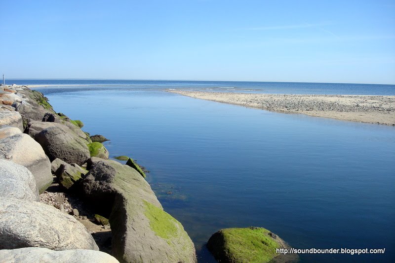
About this time last year, I spent a day wandering around Long Island's North Fork. I had no real agenda or destination, so when I stumbled across something interesting I would stop and explore further. One of the highlights of my day was Inlet Pond Preserve on the outskirts of Greenport.


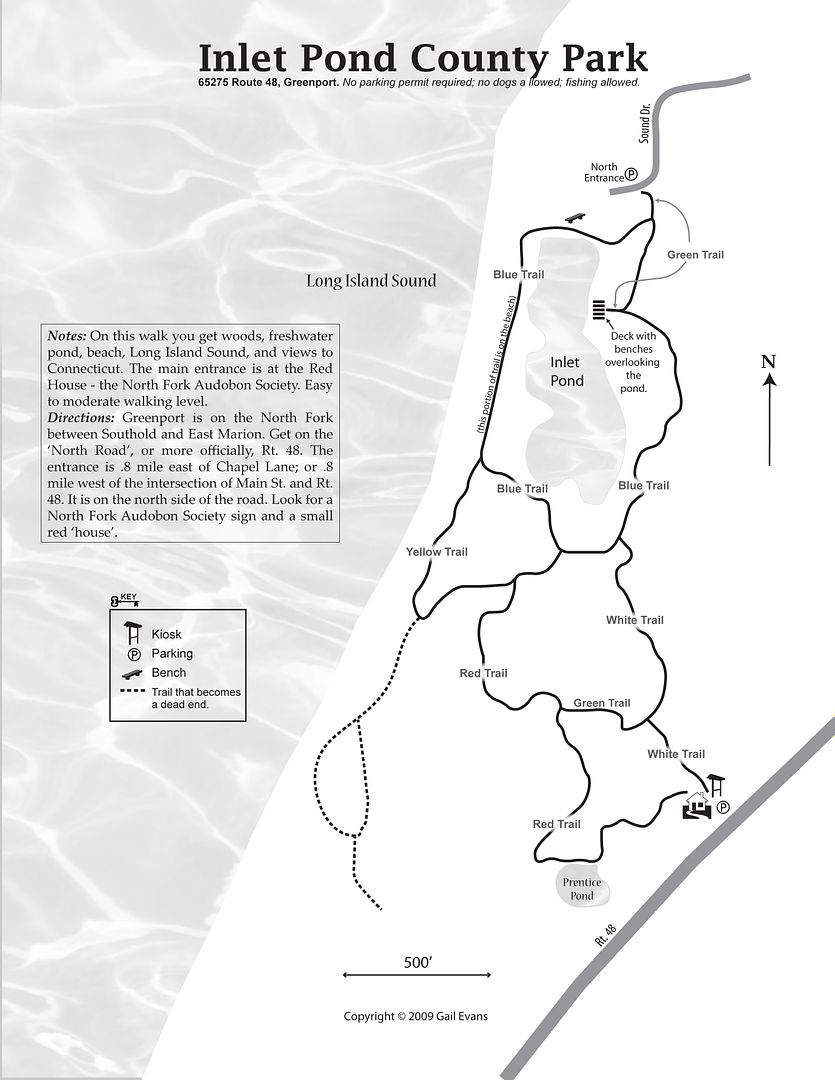
Consisting of approximately 50 acres, Inlet Pond is a county preserve maintained in cooperation with the North Fork Audubon Society. There are a network of trails that wind their way around the property; I followed the Blue Trail which circles the pond and leads to the adjacent beach.

Despite the name, there is no inlet connecting Long Island Sound to the pond. My first guess was that an inlet once existed, but had been sealed shut from some long forgotten storm.  Several websites however, claim the pond is freshwater. If I were a better investigative reporter, I would have verified the salinity myself. Shoulda, coulda, woulda!


After combing the beach and circling the pond, I arrived at an observation deck which provided a nice overview of  the land I had just walked. On one side, the pond was protected by a few short bluffs that were quickly losing their autumn color. And on the other, just a thin spit of sand was all that separated it from that "domesticated body of water"*  known as Long Island Sound.


North Fork Audubon

From The North Fork

Gail's Trails: Inlet Pond (map)


*quote: F Scott Fitzgerald; The Great Gatsby

Saturday, 25 September 2010

Cedar Point, East Hampton


There are thin slices in the year when everything seems to come together. The winds pick up, the skies are clear, the crowds disappear, and the world is yours. It's as if someone left you the keys to paradise since they won't be needing it any longer. It's a time of year I feel most comfortable in and around Long Island Sound. A moment in time when even a place like East Hampton becomes my long-lost hometown.
If I were a film director, I might very well have situated a coming of age movie in Sag Harbor and Shelter Island Sound. I spent many summers here working aboard a 53' Hatteras and calling these waters my own Along with Norwalk in my high school years, it is where everything, good or bad seemed to happen to me between ages 18 and 24.
But time rolls over everything, and I no longer have the attachments I once had to Sag Harbor. The docks in town are terribly expensive, and much of the atmosphere has changed too. The little bar I used to visit is now an upscale restaurant with a name I can't pronounce. The bookstore is gone; so too is the hardware store ; and few seem to remember any of the names of  people I once knew here.  


While the towns have changed, the waters never do!


Just east of Shelter Island and northeast of Sag Harbor is an anchorage I refer to as Cedar Point. Cruising guides rarely  mention it, and when they do, it is just a line or two. The charts call it Northwest Harbor, but I have yet to meet someone who uses this name. While never crowded, the anchorage can be uncomfortable in the summer months from the wash of passing mega-yachts circumventing Shelter Island.  When the late summer winds are not too strong however, from the south or west,  it becomes an ideal location for a night on the hook.
The surrounding land is part of Suffolk County's 600 acre Cedar Point Park. Much like Napatree Point, it is a narrow sand spit dividing the calmer waters on one side from the more exposed. And just like Napatree, the land here was altered by the Hurricane of 1938. Prior to that storm, the 1860 lighthouse and western half of the point had been an island.
Rowing ashore, we had the beach all to ourselves. While the south shoreline was hot and windless, the northern side had enough breeze to remind us that these warm days were numbered. We managed to walk a good portion of the peninsula, catching the view of a fishing boat passing  every now and then.. By late afternoon, with the sun already low in the sky, we were back aboard for an early dinner.
The shorter days make it seem much later aboard than it actually is. It's as if I enter a different time-zone and need to set my watch forward, the moment I cast the lines. There was no activity on the water and only a few stray lights could be seen in the distance. Surrounded by darkness and silence, along with the warmth of an extra blanket, I was asleep before 9 p.m..
Why is it that a 50 degree September morning feels colder than 30 degrees in January? It is one of the mysteries of the world to me. It was not yet dawn when I awoke, but I had no desire to climb out of my bunk to check the time. After unsuccessfully trying to sleep a bit more, I soon noticed the skies through the cabin portholes, slowly changing from black to pale. In no good humor, I abandoned my bunk and faced the chill of early day.
I lit the stove and  lingered alongside it, embracing the traces of heat while the coffee brewed. The wind was calm, with just the sound of water slapping lightly against the hull. Sliding back the companionway hatch, I was greeted by the sunrise of another spectacular day. I climbed on deck, easily reminded of why I loved it here so much. It was good to be back.


Friday, 30 July 2010

Saturday, 17 July 2010

Eatons Neck Coast Guard Station


When I was about 12 years old, my parents along with myself and two younger sisters, swam ashore at Eatons Neck Basin and took an informal tour of the Coast Guard station. I don't think we entered any of the buildings, but instead just walked around the grounds and got a close-up view of the lighthouse and station. It was early on a Sunday morning and so long as we stayed out of their way, the Coast Guard crew did not seem to mind our visit. Some other people anchored nearby had the same idea, and like us, they were on their way about 40 minutes later.

When I anchored here last summer, the station was off-limits to visitors. This was really no surprise as many stations began restricting access as early as the 1980's. Those that continued an open-door policy, soon changed following September 11, 2001.


There are four Coast Guard stations presently located within Long Island Sound: Kings Point, Eatons Neck, New Haven, and New London. Just beyond the Sound are the New York Harbor and Montauk stations, while the Block Island station is now closed.


Coast Guard Station Eatons Neck is the only local station to have a lighthouse on its grounds. The lighthouse was built in 1799 and is the second oldest in the State of New York (Montauk Point is the oldest). A life saving station has existed here since the early 19th century, while the present Coast Guard station was built around 1875.

With a few exceptions, I have  found the stations to be very attractive. Many of the buildings are from the late 19th century, and often look like some waterfront prep school high upon a hill.  The white clapboard siding, red shingled roof, and large flagpole are a sure giveaway however, that this is a Coast Guard station (or once was).

In recent years I have noticed that many of the boathouses appear to be falling into disrepair. My guess is that as boat technology has advanced, the boathouses have become obsolete. Today, many of them seem to be used as a storage facilty or repair shop. If you look closely at the photos above, you can see holes in the roof.

Last week while I was preoccupied with the grounding of the Alabama, a fire broke out at the Coast Guard station in Menemsha, on Martha's Vineyard. According to reports, the boathouse and docks were destroyed by the blaze. I have yet to hear whether or not they plan to rebuild. Whatever they decide, it seems unlikely a new structure will match the character and charm of these old red headed ladies by the sea.


USCG History: Eatons Neck Coast Guard (vintage photos) pdf

Coast Guard USA: Station Eatons Neck

Eatons Neck Auxiliary

Lighthouse Friends: Eatons Neck Lighthouse (map included)

Vineyard Gazette: Menemsha Fire Destroys CG Boathouse

Soundbounder: Eatons Neck Basin

Sunday, 27 June 2010

Power Crazy: Shoreham Nuclear Power Plant


The Shoreham Nuclear Power Plant has been in the news my entire life. When I was 3 months old, plans were announced in 1965 for three nuclear power plants to be built on Long Island: Lloyd Harbor, Jamesport, and Shoreham.  While the Lloyd Harbor plan was killed in 1970, and Jamesport never left the drafting table,  construction began on the Shoreham plant in 1973. Today, it remains the only completed nuclear power plant to never generate electricity.
This is not a No-Nukes post; I personally believe nuclear power should play a vital role in our domestic energy policy. Instead, this is a post against Bad Ideas. Shoreham was riddled with them .


  1. The plant was to be situated near the path of airplanes landing at MacArthur Airport and the New Haven Airport.


  2. It was to be built in an area that the U.S. Air Force had designated as "high hazard" due to its proximity to the Calverton Naval Weapons Industrial Reserve Plant, where Grumman military fighter planes were tested, which was five miles from the Shoreham site


  3. Evacuation plans called for the 3 million residents of Long Island to seek safety by automobile transportation, westward via New York City bridges.

I am certainly no expert on nuclear safety and evacuation procedures, but #3 hangs out there like a big matzo ball. Doesn't sound like much of a plan. Long Island has one way in, and one way out. Building a nuclear power plant there made about as much sense as building one in Wellfleet or Key West.
**********
My day in Shoreham was not all a loss. I eventually made it back to Rocky Point and had a wonderful dinner with Marianna and Ralph. She is from Italy via Japan, while he is from Berlin. They are in Long Island For A Year while Ralph works at Brookhaven National Labratory. Good food, good company, great conversation!


One must wait for the sundown to see how splendid the day has been
� Sophocles

Tuesday, 22 June 2010

Power Crazy: Shoreham Breakwater


At the eastern end of Shoreham Beach, the ill fated Shoreham Nuclear Power Plant comes into view.  It sits about a thousand feet inland along the Wading River, which serves as the border between the towns of Riverhead and Brookhaven. A hundred feet south of the beach there are fences with signs warning people to "keep out". With no intention of trespassing, I stayed close to the waterline as I continued eastward. There was a jetty ahead with a dozen or so people on it, and I decided to take a closer look.


It is a relatively safe jetty that was easy to walk, and there were no signs stating that it was private property. There was a couple sharing a boxed lunch while the others all appeared to be fishing. Halfway out, I heard a horn being blasted from the beach area behind me. Turning around, I saw a security-type SUV with two large men approaching the breakwater.
I would never succeed as a tabloid reporter. My camera is able to record video, but at that moment, it never occured to me. Instead of filming what was taking place, I slipped the camera back into my pocket as the two men approached.
The only thing he said to me was "You're under arrest, stand over there" as he pointed to the beach area adjacent to the jetty. They never identified themselves, and there was no logo on their shirts, but I knew they were not cops. I assumed they were from the power plant, but I was not completely sure.
I really wanted to explain to them that I was scheduled to be in Rocky Point for dinner at 6 pm. But, rather than dig myself into a bigger hole, I followed orders and walked back to the beach. They proceeded to round everyone up as they made their way out the jetty. Some sort of confusion developed with one group, and at that moment, I made the decision to run. Sweaty and out of breath, I reached the car and got the hell out of Dodge.
Soundbounder the fugitive!


Monday, 21 June 2010

Power Crazy: Shoreham Beach


I had never heard of a beach being closed on Fathers Day weekend before. There have been threats of closings that were fortunately avoided, but I have never arrived at a beach on a summer weekend and found it padlocked. That all changed when I arrived at Shoreham Beach on Saturday.
Winding along North Country Road,  I spotted 7 or 8 cars parked near the entrance to this beach, operated by the town of Brookhaven. My initial reaction was that the parking lot was full, and the overflow resorted to using the shoulder of the road. Perfect weather on a Saturday in June; "the beach is packed" I thought to myself. But as I neared the entrance, I realized the gates were closed. No problemo; I grabbed my bag and began the half mile trek up the access road that leads to the beach.
It was an easy walk, but I was by myself and traveling light. If I had children with me and several items to carry, it would not have been feasible. I found myself brainstorming different scenarios as to why the beach was closed: was the road ahead washed out; maybe there was some sort of contamination from the nearby Shoreham plant; or perhaps there was another entrance I was unaware of.
While there are many stretches of  Long Island Sound I am quite familiar with, the 25 miles dividing Port Jefferson from Mattituck remain mostly a mystery to me. With no harbors, the towns along this uninterupted shoreline were never a place to visit by boat. Other than a few scenic-route drives returning from Greenport, my only exposure to this area has been from several miles offshore.
It is a long, lonely, shoreline that is mostly deserted, except for the occasional shore club or town beach, spread out at the bottom of a ravine. Atop the bluffs, a water tower and random house are all that break the horizon and allow one to mark their progress. A dune buggy, or a fisherman in an old jeep might be the only welcome distractions. 


Arriving at the beach, I found just a handful of people scattered across the endless sand. I wanted to find out why the beach was closed. Near the pathway that descends the bluff, I asked a couple who were leaving, but they only responded by shouting "What?", before continuing on their way. Another group of 5 made sure to look away as I approached. Maybe I looked like a town constable, I don't know.
But as I started walking eastward along the beach, I noticed a girl about my age (alright, a middle aged woman), with way too much makeup and too small a bathing suit, staring at me. She yelled something out to me, that I didn't comprehend.  JACKPOT!!!!
Her name was Michelle and she wanted to know if the gates were still closed.  I told her they were, and she proceeded to tell me the different theories as to why the beach was closed. Lying on her back and moving her legs in a windshield-wiper motion, she said she had heard several stories. One story claimed Brookhaven was overrun with illegal immigrants using the beach. Another involved late night parties and vandalism. The third was that the town was broke and could not afford to open the beach.
She asked me if I wanted to hang around, but I told her I had plans to meet some friends in Rocky Point later in the day. "Oh you are meeting friends" she responded. Rather than waste the next hour convincing her I was straight, I bid farewell and wandered eastward. In retrospect, I really should have taken a picture of her; she was a piece of work.
I continued on, meeting a college couple with a kayak and fishing pole, who were just waking up, and two ederly men with their grandchildren in a beached dory loaded with the summer essentials. They all told me  variations of the same stories. I found it odd that the reasons a beach was closed on a June weekend was still left to speculation and rumour. Why was there no community outrage? Was there a community? Had these small agricultural and weekend towns sold their soul to CVS and Home Depot long ago? Were the hungover college lovers, the two grandpas, Ms Cameltoe, and myself, the only people determined to visit a beach instead of spending a summer day at the mall?


Personally, I don't buy any of the reasons for closing Shoreham Beach! If there has been vandalism or trouble after-hours, restricting access to everyone does nothing to resolve the issue. Turning the beach into an abandoned park solves nothing. It only punishes those who are not a problem. As for the budget issues, in the broad sweep of things, beaches and parks are not the reason towns are broke. Also, it would be interesting to see how many corporations in the town of Brookhaven are screaming about socialism, yet also receive taxpayer subsidies.
There is more to this story, but it will take me 3 posts to complete. About a year ago, I wrote a post stating that if I was using a grading system, Caumsett State Park would receive an A, maybe an A+. I never chose to implement that grading system, but if I did, Shoreham Beach, despite its beauty, would receive an F, maybe an F-.


To be continued


Saturday, 5 June 2010

Hometown Huntington


Trustee Park, Cold Spring Harbor, April 2010


To me, Huntington has always meant Huntington Harbor and nearby Huntington Station. The town of Huntington however, also includes Cold Spring Harbor, Centerport, Northport, along with Eatons and Lloyds Neck. The town is a diverse and attractive collection of harbors and villages that creates one of the more appealing stretches of Long Island Sound. It also has a large number of parks and beaches.
On Monday, June 7, WLIW will premier Hometown Huntington at 8 pm. The program looks at the town's maritime past, as well as the people who live there today. WLIW asked me to put this post together, and although I have not seen the program, I agreed without hesitation. Their Shoreline Sonata and Leisurama programs were both excellent pieces of work. If Hometown Huntington was made with the same quality and detail, then it is certainly worth viewing.


Friday, 7 May 2010

The 7:05 Out Of Noank


Officially, Fishers Island belongs to the State of New York. It's shortest distance to the mainland however is with Rhode Island. It has a Connecticut zip-code, an east end of Long Island area-code, and views of Block Island. To reach the island, one must take a ferry from New London (there is a small airport too).
Most of Fishers Island is private and residential. As you may have already guessed, it is also very expensive. Much of the work that takes place here is performed by off-island residents. The girl at the pharmacy, the landscaper, and the electrician are often residents of southeastern Connecticut who commute here daily. That's where Baby Doll comes in.
Along with one other boat that I am aware of, Baby Doll departs Noank twice each morning and ferries workers to West Harbor on Fishers Island. In the afternoon, she does it all again and returns them home.
Sure beats the Cross Bronx Expressway!


Tuesday, 4 May 2010

Northport Village Pier


A friend of mine considers Northport  to be the nicest harbor on Long Island Sound. I wouldn't go that far, but I can certainly understand why he would make such a claim. It has a lot of positive attributes: a fjord-like harbor that is well protected; a walkable village ; and a waterfront park with this attractive pier.


There has been a public dock here since the early 19th century, but by 1920, it had fallen into decay along with much of the surrounding waterfront. It was at this time that the village purchased the land to form the waterfront park that exists today. 


Northport Village Dock: Snow Photos 
JoAnn Corretti Painting Gallery: Northport Village Dock 


Saturday, 17 April 2010

Ambro Wetlands Preserve


It's still winter in the marshes. Maybe that is an overstatement, but many of the wetland areas on Long Island Sound are a month behind their neighboring drier lands. This was very apparent when I visited the Ambro Wetlands Preserve which is tucked behind Crab Meadow Beach in the town of Huntington. While the trees along the road were in full bloom, they began to lose their green as I approached the marsh. In a sort of Wizard Of Oz moment, I was met by a brown landscape that had the appearance of early March, rather than the second week in April. Despite air temperatures of 70 degrees,  the water temperature is still in the low 40's.


During my sophomore year in high school, one of the books assigned by my biology class was The Life And Death Of A Salt Marsh. Maybe I was too young, but the book had no impact on me. I am not even sure I finished reading it. This winter, I read it again and was completely consumed.


The chapters devoted to the seasons of a salt marsh were especially clear as I walked along the creek that winds its way towards Smithtown Bay. The low tide had exposed much of the marsh to the strong rays of sun that heated the landscape. But it would not last for long. Within a few hours, the rising tide would flood the grasses with 40 degree water, halting the spring progress for the day.


 In some areas, the high water mark was visible from the heavy rains of the past month. Many of the areas I walked were most likely submerged for days during those storms. There was a line I could see where the green of April met the cold of March.
Spring will come to the salt marsh, but not so fast. As for me, I am thinking of reading the Great Gatsby and Moby Dick once again. I hear they are very good.


Wikipedia: Jerome Ambro