Showing posts with label rivers. Show all posts

Monday, 18 July 2011

Restless Farewell


Others will enter the gates of the ferry, and cross

         from shore to shore.......
The others that are to follow me, the ties between

me and them

Walt Whitman: Crossing Brooklyn Ferry 


As gentrification continues its scorched-earth, forward march,

I've often found reassurances in the rituals and structures 

around us which remain constant. No, not silly nostalgia for 

some make-believe past, but instead a tangible connection to 

those provincial traits which help define the towns and people 

of Long Island Sound.
There are the baymen of Oyster and Huntington Bays, who 

still work their shellfish beds manually. The wooden 

oysterboats of Norwalk, Stratford, and other shoreline towns. 

Then there are the lighthouses; the 18th and 19th century 

villages; and the farms of the North Fork and the

Connecticut River.

 These are not museum relics, but instead, working 

links to our past which carry on. Stripped of them, we 

inch closer to every other shoreline town which sold its 

soul to postwar Los Angelization long ago.


The Rocky Hill-Glastonbury Ferry is believed to be the oldest

continuously operated ferry in the U.S. Established in 1655, it 

became a state operation in 1915, surviving the Great Depression,

the Floods of 1936, and several ill-conceived highway overpasses

in the 1950's and '60's. 

Just a barge pushed by a tugboat, she is highly functional, but never  

glamorous. Sadly, she met her fate with the budget-cuts this week. 


About 25 miles south of here is the Chester-Hadlyme Ferry. She is 

considered to be the second oldest continuously operated ferry in 

the U.S.. Linking a prettier, more affluent stretch, with museums

and parks overlooking the river, this boat is the more popular of 

the two. Somewhat famous, she is an appealing September/October 

fall foliage excursion, and provides an important transportation 

link along this 16 mile bridge-less stretch between Saybrook and 

East Haddam.


But pedigrees, logistics, and big-pictures don't carry much 

weight in Hartford. The Chester-Hadlyme Ferry has been 

axed along with her older sister to the north. There has been 

a lot of talk about how neither of these boats make money, 

but that argument is selective, penny-wise, and pound foolish. 

No form of transportation makes money without public subsidies. 

Highways, airports, shipping terminals, etc, all lose money 

without government assistance. 


Both ferries are scheduled to close on August 25.
I've thought about taking one final boat ride, but 

what good would it do? Maybe, instead, I'll go find 

some franchise restaurant along the CT Turnpike 

or Long Island Expressway which serves generic 

jalapeno poppers, hot-pockets, fish-a-ma-jig 

sandwiches, and booze.

I'll sit in one of those formica cubicles, partitioned 

by the glazed glass ovals depicting lighthouses, 

oystermen, church steeples, ferry boats, and 

everything  else we chose to abandon.


Chester-Hadlyme Ferry

Sunday, 19 June 2011

Quinnipiac River Park


North of Interstate-95, above the Ferry Street Bridge, the decaying industry along New Haven's Quinnipiac River gives way to this historic stretch of waterfront. With a high concentration of 19th-century homes, the neighborhoods of Fair Haven, and Fair Haven Heights are a modern day reminder of New Haven's maritime past.  
This was once a prominent oyster port, with wharves and sheds lining both sides of the river. Related industries, such as shipbuilding and barrel making, thrived as well. By the 1840's, the neighborhood became a leading center for processing and trading, as oysters arrived from as far away as the Chesapeake and Delaware Bays. 
Today, things are a bit quieter here, but the oystering lives on, albeit on a lesser scale. Taking in the view from Quinnipiac River Park, I could see an oyster boat quietly at rest, with a tell-tale pile of shells rising behind her. A limited and diminished reminder of a once dominant past.


New Haven Preservation Trust: Quinnipiac Historic District 
CT Coastal Access Guide: Quinnipiac River Park
Mystic Seaport: New Haven Sharpie


Thursday, 16 June 2011

Connecticut River Shad


Did you know there is a commercial fishery for shad on the Connecticut River? Seasonal, small-scale, and often hidden from view, the fishery goes largely unnoticed with the exception of a random shad bake. American shad normally return to the Connecticut River sometime in late April and continue through June. Once the river warms up, the shad spawn, and the season comes to an end.


Tucked away on the river's bank near the Rocky Hill Ferry is Hale's Shad. It's an unassuming type of place,to say the least: just a bare counter-top, a list of prices, and some photocopied recipes taped to the wall. Hale's stays open during the spring run, selling nothing but shad, roe, and something called shad milt.

"Marketed" as an aphrodisiac, every customer at Hale's got a sales pitch for shad milt while I was there. Having already eaten six oysters for lunch, I didn't want to get carried away, so I politely said "no thanks".


Wikipedia: American Shad

UMassEdu: Poor Man's Salmon

Map: Hale's Shad

Monday, 9 May 2011

Bon Voyage Empire State


Maritime education is not something generally associated with Long Island Sound, until you actually take the time to think about it. There is the U.S. Coast Guard Academy in New London; the U.S. Merchant Marine Academy at Kings Point; and SUNY Maritime College at Throgs Neck. Those colleges, combined with the oceanography programs at SUNY Stony Brook and UCONN Avery Point make the Sound one big nautical classroom
While students at more conventional schools are presently thinking about final exams and summer vacation, students here are instead preparing for a semester-at-sea. Hands-on experience, outside the classroom, aboard a ship.
Empire State VI, a converted 565 foot bulk cargo freighter, serves as the training ship for SUNY Maritime College. She and her crew depart this morning for the Mediterranean. Bon voyage...see you in September!


Wikipedia: TS Empire State
Kings Point Waterfront: Summerwind in DC

Thursday, 17 March 2011

Norwottuck Rail Trail


When I look at the Connecticut River north of Hartford, I have to sometimes remind myself this is the same river where Carina spends her winter months. While I am well acquainted with the river's path from the Quebec border to Saybrook Point, I don't instinctively connect-the-dots for these agricultural and mill towns  scattered along its bank in western Massachusetts.
Northampton is approximately 75 miles north of the Sound, as the crow flies. The river however, follows a more twisted and indirect path, adding perhaps 40 miles to its flow towards Long Island Sound. If one were to paddle this portion of the river, you would spend a significant amount of time heading east and west, in order to travel south.
Thankfully, I hadn't arrived here by river-raft or canoe; I was staying at my sister's house just a few minutes away. One day last month, while she was still asleep, I took an early morning walk along the Norwottuck Rail Trail, which includes this 1879 bridge.  The ten mile, former railroad line connects the city of Northampton with Amherst, MA. According to the website, it is one of the "most popular facilities in the Pioneer Valley".


Old bridges make old noises! The frozen wood planks atop the cold steel made a sort of cracking bang with each step that echoed off the ice flow. Several times I had stopped for a moment to take in the silence, before quickly moving on. Silence may be golden, but it was cold out, and I don't like standing still.  
When I reached the east side of the bridge, I could see farm fields and the encroaching sprawl on the whitewashed horizon. It was then that I realized I had passed through here before.
Returning from Vermont last summer, I had taken a slower, more indirect route through this obscure stretch of river valley. Steering clear of the interstate, I meandered southward on county roads through tobacco farms  and vegetable fields. With the windows wide open and my bare foot on the dash, I had stopped at a small store for a seltzer and a phone call.
 It was now clear to me that the same store was directly in front of me.


It's strange how people and places of little significance can reappear later in life, under completely different circumstances. A negative streak intersects with a previous, unrelated positive path. The good times and the bad get all tangled together - interwoven is too orderly a word.
This trip to Northampton didn't have the carefree feel of that late summer drive. I was passing through town on a much more serious matter. This time, the glass was half-empty and there was no way to make it half-full. The farmhouses and colonials no longer boasted an aura of riverside, orderly bliss.  Instead, I looked out at the clapboard, and wondered about the modern day turmoils taking place inside the facade. 


Norwottuck Rail Trail: website
Northampton MA: Map


Bruce Springsteen: The River


Wednesday, 6 October 2010

Saugatuck Rowing Club


The Saugatuck Rowing Club has become such a fixture in Westport that it is easy to forget they have been around for just twenty years.  A former Fordham University coach and oarsman with the Garda Siochana Rowing Club in Dublin, Ireland, James Mangan founded the club by converting an abandoned rail freight station into a boathouse on the banks of the Saugatuck River. His goal was to introduce rowing to people of all ages and make the sport easily accessible.

I think it is safe to assume his goal has been accomplished. The "boathouse" is now an impressive 15,000 square-foot building with a fitness center, restaurant, locker rooms, as well as a large boat storage facility. The property and grounds are equally attractive.
With three straight days of blustery, damp conditions, I didn't expect to see much activity here on a Tuesday afternoon in October. I could not have been more wrong however, as the club was as busy as a sunny day in June. Young rowers made their way up and down the river, followed by a coach in a small motorboat. Viewers like myself, stood in the foggy drizzle and watched the action from atop the bank. I know very little about crewing; my closest experience was drinking beer at the Head Of The Charles Regatta in 1986. But I do know that I enjoy watching it, and apparently, many other people do too. The dreary weather made for poor photography, but the atmosphere was bright and fun. 
One other thing I like about the Saugatuck Rowing Club is the handful of spaces along the south end of the lot reserved for "public parking". It is a nice touch from a club that has found amazing success, but hasn't forgotten its roots and original intent.


Soundbounder: Orchard Beach Lagoon

Monday, 23 August 2010

Essex Museum Fire


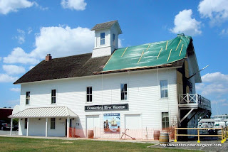
 A fire earlier this month at the Connecticut River Museum in Essex resulted in significant damage to this waterfront landmark. On the evening of August 11, firefighters from three towns responded to the blaze which engulfed all three stories on the east side of the building.
Built in 1878, the building served as a warehouse for the many steamboats travelling the river. Threatened by commerial developement in the 1970's, a nonprofit group organized and created the riverside museum which exists today. Focusing on both the Connecticut River and local maritime history, it is one of the nicer regional museums I have visited.
While the fire caused significant structural damage , the museum's collection of artifacts was saved. They were forced to shut down for a period, but the museum was open to the public once again this past weekend.


Soundbounder: Mary E

Sunday, 16 May 2010

An Occurrence At Old Lyme Bridge


No matter what the calendar and thermometer may read, it is the Old Lyme Railroad Bridge that marks my seasons . When I sail north of this span in November, the bridge closes behind me, and my winter begins.

For the past several years, Carina has spent her winter months in a boatyard a few miles above this bridge. I still sail her occasionally in late fall and early spring, but always north of the span. Until I venture to the other side, it all seems like a preseason exhibition game. It doesn't really count. This 1907, truss-style, bascule bridge is my Checkpoint Charlie; my San Ysidro. Passing beneath her is my spring and autumnal equinox.


There is something that feels very unnatural when a boat passes under a bridge. The charts and signs all show that there is plenty of clearance, but I still find myself second guessing the dimensions. I envision the mast being too tall, hitting the bridge, and then falling down. If only Freud were aboard to diagnose and explain my  mast-envy, and dismasting anxiety.
But there are no mishaps, and the bridge operator gives me a wave as I clear the opening. I turn to wave back and immediately realize that I am south of the bridge. "See you in November" I yell to him.
Ahead of me I can see the two lighthouses at Saybrook Point, and I smell the salt water in the breeze. A small wave rolls in from the Sound and smacks the hull broadside, spraying my face lightly. It's a brisk and salty reminder that Carina has been released from her winter stall, and is now free to roam in what F. Scott Fitzgerald called "the great wet barnyard of Long Island Sound". 


Soundbounder: November
Soundbounder: Ferry Landing Park

Thursday, 13 May 2010

Monday, 15 March 2010

Nor'easter


It seems like many years since we have had a storm of this magnitude.While nor'easters are certainly common here between October and April, this weekend's storm appeared to carry an extra punch. Wind gusts as high as 74 MPH, combined with 5-plus inches of rain, knocked down trees and power lines across the northeast. Many low lying coastal areas are flooded, with the hardest hit regions being Fairfield and Nassau Counties.
The nor'easter I measure all others by, was one I did not witness personally. The 1992 storm combined severe wind and rain with high tides that flooded entire neighborhoods. Many harborside bars still display photos of one of their regulars rowing down the street or wading through water up to their waist. The high-water mark at the City Island Yacht Club remains visible on the clubhouse exterior. I have met numerous people who lost boats or had their homes damaged from that storm.
On Sunday during a break from the winds, I visited a boatyard in Old Saybrook. I had hoped to go out to some of the beach areas, but flooded streets and downed trees prevented me from doing so.The few boats  in the water were now tied to docks that were submerged. The hauled boats meanwhile, sat in a flooded yard. Hopefully that is the extent of the damage.  
While this weekend's storm was not as destructive as the 1992 nor'easter,  the effects of it will be visible for years. I am sure along many stretches of Long Island Sound,  there are  beaches that have been altered, homes damaged, piers destroyed,and lives lost.


Monday, 7 December 2009

Chester Hadlyme Ferry


Chester-Hadlyme Ferry, October, 2009

CT.gov: Ferry Schedule

YouTube: Ferry Crossing

Soundbounder: Restless Farewell (budget cut)

Map


Note Gillette Castle in the upper left corner

Friday, 6 November 2009

Smyth Sanctuary & Pratt Cove Preserve


On a winding road connecting Essex and Deep River are two protected areas, side by side. Smyth Sanctuary and Pratt Cove Preserve both overlook the freshwater marshes here that feed the Connecticut River. They are areas best explored by a kayak or canoe.
Pratt Cove Preserve was donated by Susan Haig and is managed by the Nature Conservancy. The preserve includes a short trail, along with a launch area. Despite being freshwater, the cove is tidal, with a current that looked fairly strong when I visited.
Across the street and slightly south, is the Smyth Sanctuary. This is a wooded area maintained by the Deep River Land Trust. There did not appear to be any trails, but a viewing platform provides an attractive view overlooking the marshlands that make their way to the Connecticut River.
*
Nature Conservancy: Pratt Cove
CT Coastal Access Guide: Pratt Cove

Wednesday, 6 May 2009

Saybrook Point


Years ago when I was about 7 or 8 years old, we stopped at Saybrook Point for lunch during some extended road trip along Interstate-95. One of the small buildings here served fried seafood and steamed clams on a picnic table patio. They must have had good prices because my parents let all of us kids order whatever we wanted. I ordered the fried clams.
Previously, the only fried clams I had eaten were the clam strips offered on the childrens menu of all the Howard Johnsons that once lined the turnpike. When my order of whole-belly clams arrived, I was more than a little surprised. In typical 8 year old fashion, I spent about five minutes playing around with each clam, never quite sure when to stop chewing and finally swallow. When no one was looking, I tossed a few half-chewed lumps to the gulls. Eventually my father moved in and finished my plate.
The clam shack is now gone; replaced by some overpriced, upscale, tourist trap selling frozen shrimp with views of the river. There are some exceptions, but I am usually skeptical today of many of the waterfront eateries. Too many of them are selling the same food that can be found in Omaha or Bakersfield. You pay for the view, and the fantasy that your meal arrived via the docks, rather than the interstate.
Saybrook Point offers an attractive view at the mouth of the Connecticut River. There are restrooms, benches, and a miniature golf course. There is also a building called The Pavillion that is used for town functions and is available for rent. This is a nice spot to watch the activity on the river.
As for the whole-belly clams,,,,....they are now the only type I will eat. No offense, Howard Johnson.

CT Coastal Access Guide: Saybrook Point
Map

Saturday, 17 January 2009

Little Bay Park


It began in 1883 when the Brooklyn Bridge spanned the East River, connecting lower Manhattan with Brooklyn. In the years that followed, each decade seemed to produce a new span that linked Manhattan and the Bronx, with Brooklyn and Queens. By 1961, there were eight bridges and more than a dozen tunnels traversing the divide of the river. 48 years ago this week, in a sort of golden spike moment, the Throgs Neck Bridge opened. From the Battery Tunnel to Long Island Sound, the East River had been conquered from both above and below.
To the best of my knowledge, that is not exactly how the opening of the Throgs Neck Bridge was viewed. Newspaper articles of the day reported it as one more link of a bigger plan that would continue eastward. Throgs Neck was built to ease traffic congestion on the Whitestone Bridge, and there would be future bridges across the Sound to ease the traffic of the Throgs Neck. There were already plans in the works by Robert Moses for a Rye-Oyster Bay Bridge, a New Haven-Shoreham Bridge, and an Orient Point-Rhode Island Bridge. Each project promising to solve the traffic congestion created by the previous bridge.
Obviously, these bridges and tunnels were never built. But every so often, the issue is resurrected again as a cure-all for our traffic problems. The latest version is a tunnel extending from Interstate 287 to Oyster Bay. This project has most likely been shelved due to the current fiscal crisis, but it will reappear when prosperity returns.

Little Bay Park is a thin parcel of land wedged between the Cross Island Parkway, Fort Totten, and the Throgs Neck Bridge. When I visited recently, there were many joggers, as well as people walking their dogs. A few visitors just sat in their cars, looking out at Little Bay, and the traffic jam on the bridge that marks the entry to the East River from Long Island Sound.

Map

Wednesday, 3 December 2008

Ferry Landing Park in Old Lyme


I awoke early on Sunday just after 5 AM. The house was cold, and the forecast was calling for rain and possibly some snow throughout the day. One temptation was to stay in bed. The other was to get outdoors for a little while before the weather turned bad. I had originally intended to visit Griswold Point, but that would have to wait for a sunnier day. I had taken note however, of a smaller, more accessible park in Old Lyme last month. From the cockpit while I waited for the Amtrak Bridge to open, I saw several people fishing from a pier that extended southward from the bridge through some marshland. Soon I was out of bed and on my way.
Ferry Landing Park is also referred to as the DEP Headquarters. The Connecticut Department of Environmental Protection Marine Division maintains several buildings and boats on the grounds. There is a lawn with a gazebo and picnic tables, as well as the walkways and boardwalk that I was hoping to visit. Upon arrival, I immediately noticed a sign that stated that the park was closed from sunset to sunrise. The dark clouds made it hard to distinguish sunrise from early dawn. I threw caution to the wind, and entered the park anyway (More on this in a later post).

I found my way to the boardwalk that leads under the railroad bridge and out to the marsh and tidal flats. A heavy layer of frost covered the planks, which forced me to take baby steps to maintain my balance. A light, misty rain began to fall. At the far end of the boardwalk, I came to a small observation deck that provided maybe an 8 foot advantage. The small increase in elevation however, expanded the views considerably. Great Island and the two Saybrook lighthouses came into view as well as a large area of tidal flats and marshes.
Some of the backwaters were covered with a thin film of ice. The river itself was free of ice, but the tide was slack. The tug of war between the currents of the river and the sound was in a temporary lull, as neither waters held the higher ground. Water that had made its way from small beaver ponds in Vermont and New Hampshire, would sit here for a one hour layover before making the final push to the sea. It was only a matter of time and tide.
When I awoke from daydreaming about Vermont beaver ponds, I noticed that the bridge operator had been keeping a sharp eye on me. I tossed around some ideas about why he might be watching me through binoculars. Maybe they take that sunrise rule very seriously (possible). Maybe he thinks I am a lunatic to be walking around out here on such a cold and damp morning (plausible). Maybe he reads my blog and was thrilled that the Soundbounder guy was in Old Lyme (highly unlikely). And finally, maybe he found it suspicious of me to be taking pictures of the bridge at such an early hour, on such a miserable day (very likely).
I did not wait around for the answer. I made my way back to land and waved to the operator as I passed. The wind began to blow just enough to make it feel very uncomfortable. Small ripples now covered the water surface that had been glassy just moments before. My hands began to feel numb from the cold. The rain began to freeze.

Ferry Landing Park WebAlbum