The weather cooperated today, by sending us a bit of rain, some higher humidity, and lighter winds. Although we haven't had any official words on it, I expect that the Famine Lake fire probably didn't move much further north. We heard lots of aircraft throughout the day, and guests who arrived to check in said that they saw water drops as they travelled up. The new incident command team is in place, and information and maps are making their way to us here on the south shore of Gunflint Lake. You can view much of this information, too, by visiting the MNICS website, at http://www.mnics.org, and clicking on the current fire information button.
I learned that one of the reasons that the evacuation was called yesterday was because if the wind had moved ten degrees more, the fire would have missed a swamp and headed into more favorable fuels. That would have caused it to burn hotter and faster, and with the wind, it easily could have pushed up to the Gunflint Trail. The fire moved quickly on Thursday, and with similar weather conditions on Friday, it was reasonable to assess that the fire was behaving in the same fashion as the previous day. The smoke was so thick, it was very difficult to see the front line of the fire. The sheriff felt it was necessary to call the voluntary evacuation, so that is what he did. It makes sense to act on the cautious side of things. When they were able to finally fly under the smoke column, they learned that the fire actually was still a good mile or so south of where they thought it was. That was a big relief. We're all very fortunate up here for the lucky breaks that we have gotten.
Some of our guests who checked in today were actually on a BWCA trip this week in the area that the fire was burning. On Thursday night, they were on Long Island Lake. They didn't really camp though. Instead, they spent the night watching the fire, as it had reached the south shore of the lake, approximately a half-mile from where they had stopped for the day. They were at a campsite, keeping an eye on the fire and taking turns snoozing a bit. The fire was at times an orange glow, other times they could see trees torching, and they said it was very loud. At about three in the morning, they decided that it would be better to be in a different location on the lake, because the fire seemed to be coming closer. So they loaded up their canoe and pushed off to go across to an island campsite instead. When they turned on their headlamps, they could see a white cone of smoke and ash in front of them. By morning, they had adjusted their travel plans, so that they came out at the Cross Bay entry point, near Round Lake. Although it was most certainly an interesting experience, they said that it was one that they would rather not repeat.
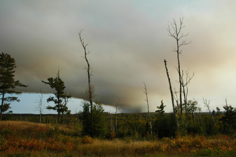 Now, for some pictures and an update as to what we were doing this past week: Thursday afternoon, Greg and I were on our way home from Duluth. I had heard that fires were burning in the area, due to lightning the week prior. I had been keeping up-to-date with them, mainly through radio reports. We were riding in the blue Toyota, which doesn't have a radio, so I was unable to hear any fire updates that day. But as we came up the trail, we could see smoke columns rising, so we knew that something had changed. As we passed the mid-Trail and Iron Lake areas, the smoke column cleared, but we could see another one up ahead, and we wondered if it could be something left over from the Cavity Lake fire. But as we approached Loon Lake, we saw that it was much closer than Seagull Lake. We stopped near the Schmidts' place, our good friends, whose driveway is pretty much straight south of our lodge. And we could see that the fire was straight south of where we were stopped. We took a couple of pictures, before heading the rest of the way home. When we got here, ash was falling from the sky.
An email told me that the smoke we were experiencing was from the Red-Eye fire. But we realized the next day that the two columns we saw were from the Red-Eye and from the Famine fires. And it was most likely the Famine fire that was sending the smoke our way. After the evacuation stuff took place, Greg and the kids went out on to Gunflint Lake, and they took some pictures from the north side of the lake. They could see lots of smoke in the sky above the ridge. Sometimes it would settle over us, and then other times it would blow on by. The lake looked like copper, much like it had the day the Cavity Lake fire had gone wild in July. The sun was glowing red, as it shone through the smoke. But for whatever reason, we happened to be smoke-free at that time, as shown by this picture of our beach, taken as they returned to this side of the lake. The smoke has been more prevalent than during the Cavity Lake fire. But then the wind will switch, it will all clear out, and once again I am smelling that sweet Northwoods air.
On a different note, some of the best news of the day was that Robert called us. He made it safely in to Fairbanks yesterday, found his good friend Ben, and is starting to settle in. He said that the drive from Eagle to Fairbanks went fine, and that it was very beautiful, thanks to lots of color change taking place up there. We told him of our excitement down here. I don't imagine that he is missing us too much yet, as he starts out on this exciting new adventure in his life. Greg has told me some good stories of his trip up there with Robert. Hopefully, those stories will soon make their way to this blog.
No comments:
Post a Comment